HOME DUST JACKET REVIEWS CHAPTER 1 CORRECTIONS PRESS RELEASE ORDER the BOOK |
ASSESSING THE VIABILITY OF A PALESTINIAN STATE
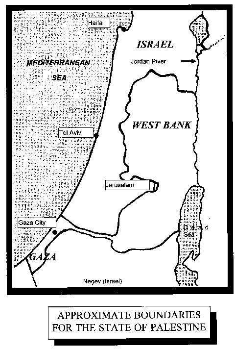
This geographic assessment of Palestine is based on the assumption that the state's borders will conform to approximately the same lines as those which presently define the "West Bank" and the "Gaza Strip." BORDERS Palestine's borders can be observed on the map at Figure 3. The state's eastern border is well defined by the Jordan River, starting slightly more than 30 kilometers south of the point from which the river exits the Sea of Galilee, and extending to approximately the mid-point of the Dead Sea. An abrupt range of mountains a few kilometers to the west of the river further defines the boundary and acts as a barrier to uninvited incursions. As the borders of the West Bank portion of the state curve around towards the west, however, they no longer follow specific geographic features, and must be statutorily defined.
The western boundary of the Palestine's Gaza portion is the Mediterranean sea. To the south, east, and north, there are no clearly defined geographic boundaries. There are no geographical impediments to either trade or invasion along the western side of the West Bank and along the eastern border of Gaza. The security implications of this will be discussed further in Chapter 6, "Security." TERRAIN AND TOPOGRAPHY The most distinctive terrain feature of the West Bank is a prominent highland area and mountain range stretching north to south from Jenin to Hebron, an area of roughly 3500 km2. Reaching elevations higher than 1,000 meters, this range towers over another major feature, the Jordan Rift Valley, which covers 400 km2 and lies at an elevation of roughly 200-300 meters below sea level. Between the mountains and the river is a 1500 km2 region broadly sloping from 800 meters to 50 meters below sea level. 1 From the western edge of the highland region toward the eastern border of Israel, the topography tends to rolling hills sloping down to the Mediterranean coastal plane. From north to south, the West Bank is nearly 140 kilometers long, and varies in width from approximately 30 to 60 kilometers. The Gaza Strip portion of Palestine is about 45 kilometers long north-to-south, varying in width from 6 to 13 kilometers. Since it is wholly contained along the coastal plane, it is virtually flat, with little terrain relief. 2 Though the mountainous areas tend to make travel and communications more difficult, the distances within Palestine are such that geography tends to have little significant impact on internal or external commerce. However, the physical separation between Gaza and the West Bank could present almost insurmountable problems, especially if Israel were to adopt a hostile posture. For this reason, most plans for creation of a Palestine state postulate a land corridor linking the two. This corridor would be just over 30 kilometers long, and two to four kilometers wide. 3 Further implications of the corridor will be discussed under "Transportation and Communications Infrastructure" in Chapter 8. The diverse terrain, particularly the steep mountainous and hilly areas greatly effect land usage. Nearly a third of Palestine's land is of marginal or no value for agriculture because of sharp gradients, rockiness, alkalinity, or aridity. The mountains, however, counter some of their disadvantage by catching moisture-laden clouds and coaxing precipitation from them. CLIMATE Palestine has a surprising variation in climate for a country of relatively small area. Overall, it possesses a Mediterranean climate, with long, hot summers, and short, mild winters. The Jordan valley, however, is significantly hotter and drier, while the highland region stays noticeably milder in the summer, and has been known to receive significant quantities of snow in occasional winter storms. Most (70%) of the annual precipitation falls between November and March, and averages 650 millimeters (mm) (about 25 inches) in the central highland areas, generally decreasing in amount towards the south and towards the east, with the Jordan Valley and Gaza receiving 200 mm (7.5 inches) or less. Annual precipitation amounts can vary dramatically from year to year, but on average precipitation is only adequate to support a population. All in all, the climate is conducive to long growing seasons, with year-round farming possible in some areas. Excessive heat can be a hazard in desert areas, but other than drought and occasional large thunderstorms and flashflooding, there are few climatic or weather hazards in the region. 4 Other areas of the world with comparable climates include Amarillo, Texas and Sacramento, California in the United States, and Madrid in Spain--although the two US locations tend to have slightly higher and lower extremes in temperature. 5 LOCATION Located at a point where three continents come together, Palestine is at an historical nexus of cultural ferment, trade routes, and war. It is sandwiched between two logical trading partners, Israel and Jordan, and has access through Jordan to Saudi Arabia, Iraq, and the Arabian Gulf states. With a future port in Gaza, it will have further access to Europe, North Africa, and the Western Hemisphere. What might be from some aspects an enviable location has its drawbacks as well. It is vulnerable to invasion from several different quarters, and could find itself in frantic economic competition with its neighbors for the same markets with the same products. MAJOR DRAINAGE SYSTEMS The Jordan River system is the only water course of any significance. Averaging only about a meter in depth, the river is of no consequence as a waterway, but is important as a source of water for domestic, farm, and industrial use. The largest body of water contiguous to Palestine is the Dead Sea. It also is unimportant for transportation, but may be a source for mineral exploitation and tourism. A number of desert wadis provide drainage during periods of significant precipitation. OCEAN ACCESS Palestine's only outlet to the sea is Gaza's approximately 40 kilometer shoreline. There is presently a small port at Gaza, capable of handling fishing boats and small ships. Though there is no naturally sheltered anchorage, it would be technically feasible to construct a reasonably large deep-water port, providing Palestine with satisfactory ocean access. 6 ASSESSMENT
NOTES
|